
Zanjan topographic map
Interactive map
Click on the map to display elevation.
About this map
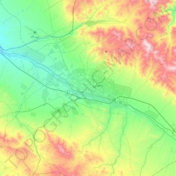
Name: Zanjan topographic map, elevation, terrain.
Location: Zanjan, بخش مرکزی, Zanjan Province, 45136, Iran (36.50998 48.32594 36.82998 48.64594)
Average elevation: 1,876 m
Minimum elevation: 1,490 m
Maximum elevation: 2,656 m
Other topographic maps
Click on a map to view its topography, its elevation and its terrain.
Zanjan
Iran > Zanjan Province > Zanjan
Zanjan, بخش مرکزی, Zanjan County, Zanjan Province, Iran
Average elevation: 1,733 m
shahrak-e--gharb
Iran > Zanjan Province > Zanjan
shahrak-e--gharb, Zanjan, بخش مرکزی, Zanjan County, Zanjan Province, Iran
Average elevation: 1,705 m