
Anacortes topographic map
Interactive map
Click on the map to display elevation.
About this map
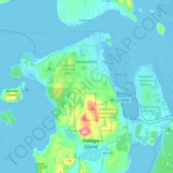
Name: Anacortes topographic map, elevation, terrain.
Location: Anacortes, Skagit County, Washington, 98221, United States (48.44799 -122.70417 48.52243 -122.52789)
Average elevation: 36 m
Minimum elevation: -2 m
Maximum elevation: 381 m
Other topographic maps
Click on a map to view its topography, its elevation and its terrain.
Mount Erie
United States > Washington > Skagit County > Anacortes
Mount Erie, Anacortes, Skagit County, Washington, 98221, United States
Average elevation: 128 m
Marblemount
United States > Washington > Skagit County
Marblemount, Skagit County, Washington, United States
Average elevation: 249 m
Big Lake
United States > Washington > Skagit County
Big Lake, Skagit County, Washington, 98274, United States
Average elevation: 80 m
Anacortes
United States > Washington > Skagit County > Anacortes > Anacortes
Anacortes, Skagit County, Washington, 98221, United States
Average elevation: 37 m
Concrete
United States > Washington > Skagit County
Concrete, Skagit County, Washington, United States
Average elevation: 125 m
Coal Mountain
United States > Washington > Skagit County
Coal Mountain, Skagit County, Washington, United States
Average elevation: 1,003 m
Sedro-Woolley
United States > Washington > Skagit County
Sedro-Woolley, Skagit County, Washington, United States
Average elevation: 28 m
Burlington
United States > Washington > Skagit County
Burlington, Skagit County, Washington, 98233, United States
Average elevation: 12 m
Mount Vernon
United States > Washington > Skagit County
Mount Vernon, Skagit County, Washington, 98273, United States
Average elevation: 37 m