
Dikhil topographic map
Interactive map
Click on the map to display elevation.
About this map
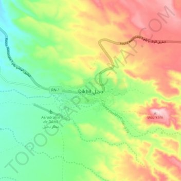
Name: Dikhil topographic map, elevation, terrain.
Location: Dikhil, Dikhil District, Dikhil, Djibouti (11.06711 42.32874 11.14711 42.40874)
Average elevation: 521 m
Minimum elevation: 402 m
Maximum elevation: 682 m
Dikhil has a Semi-arid climate (Köppen climate classification: BSh). Characterized by hot and dry summers, and mild to cool winters where most of the precipitation is concentrated (spring and autumn being pleasantly warm transitional seasons). However, due to the town's altitude and inland location, its climate features are the humidity is very low, and temperatures usually fall on 28 °C (82 °F) at night, which makes summer particularly pleasant compared to coastal cities. The rainy season extends from July to October. From November to February, the town experiences the cool winter season. It heats up from June to October, though the nights are pleasant. This elevation gives the settlement and the surrounding area a milder climate than the Djibouti city coastal area, where the weather is typically hot.