
Inwardleigh topographic map
Interactive map
Click on the map to display elevation.
About this map
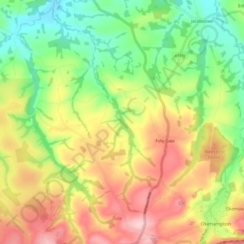
Name: Inwardleigh topographic map, elevation, terrain.
Location: Inwardleigh, West Devon, Devon, England, United Kingdom (50.73754 -4.09589 50.79652 -3.98446)
Average elevation: 163 m
Minimum elevation: 76 m
Maximum elevation: 266 m
Devon trails, hiking, mountain biking, running and outdoor activities
Other topographic maps
Click on a map to view its topography, its elevation and its terrain.
Burrator Reservoir
United Kingdom > England > Devon > West Devon > Meavy > Sheepstor
Average elevation: 255 m
Higher Cherrybrook Bridge
United Kingdom > England > Devon > West Devon > Powder Mills
Average elevation: 384 m
Wistman's Wood (Nature Reserve)
United Kingdom > England > Devon > West Devon
Wistman's Wood is one of Britain's last remaining ancient temperate rainforests and one of three remote high-altitude oakwoods on Dartmoor in Devon, England. The first written document to mention Wistman's Wood date to the 1600s, while more recent tree-ring studies show that individual trees could be many…
Average elevation: 433 m
Honeychurch
United Kingdom > England > Devon > West Devon > Sampford Courtenay > Honeychurch
Average elevation: 141 m