
Raška topographic map
Interactive map
Click on the map to display elevation.
About this map
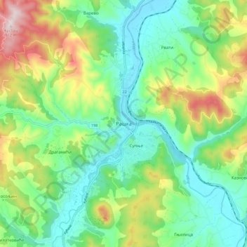
Name: Raška topographic map, elevation, terrain.
Average elevation: 550 m
Minimum elevation: 387 m
Maximum elevation: 896 m
Other topographic maps
Click on a map to view its topography, its elevation and its terrain.
Krusevica
Serbia > Central Serbia > Raska Administrative District > Raska Municipality
Krusevica, Raska Municipality, Raska Administrative District, Central Serbia, 36222, Serbia
Average elevation: 809 m
Crna Glava
Serbia > Central Serbia > Raska Administrative District > Raska Municipality
Crna Glava, Raska Municipality, Raska Administrative District, Central Serbia, Serbia
Average elevation: 1,235 m