
Burgh Castle topographic map
Interactive map
Click on the map to display elevation.
About this map
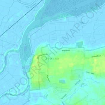
Name: Burgh Castle topographic map, elevation, terrain.
Location: Burgh Castle, Great Yarmouth, Norfolk, England, United Kingdom (52.57145 1.64664 52.60357 1.68817)
Average elevation: 3 m
Minimum elevation: -4 m
Maximum elevation: 16 m
Norfolk trails, hiking, mountain biking, running and outdoor activities
Other topographic maps
Click on a map to view its topography, its elevation and its terrain.
East Somerton
United Kingdom > England > Norfolk > Great Yarmouth > East Somerton
Average elevation: 6 m