
Tysmenytsia Raion topographic map
Interactive map
Click on the map to display elevation.
About this map
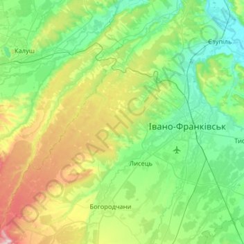
Name: Tysmenytsia Raion topographic map, elevation, terrain.
Location: Tysmenytsia Raion, Ivano-Frankivsk Oblast, Ukraine (48.75901 24.44929 49.09564 24.97233)
Average elevation: 330 m
Minimum elevation: 207 m
Maximum elevation: 696 m
Other topographic maps
Click on a map to view its topography, its elevation and its terrain.
Bukovel
Ukraine > Ivano-Frankivsk Oblast > Polianytsia
Bukovel is the largest ski resort in Eastern Europe situated in Ukraine, in Nadvirna Raion, Ivano-Frankivsk Oblast (province) of western Ukraine. A part of it is in state property. The resort is located almost on the ridge-lines of the Carpathian Mountains at elevation of 900 m (3,000 ft) above the sea level…
Average elevation: 1,009 m