Geolocate

Fincastle topographic map

Interactive map

Click on the map to display elevation.

About this map

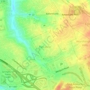
Name: Fincastle topographic map, elevation, terrain.

Location: Fincastle, Jefferson County, Kentucky, United States (38.30387 -85.54758 38.31289 -85.53583)

Average elevation: 218 m

Minimum elevation: 194 m

Maximum elevation: 236 m

Other topographic maps

Click on a map to view its topography, its elevation and its terrain.

Louisville

United States > Kentucky > Jefferson County

Louisville, Jefferson County, Kentucky, United States

Average elevation: 188 m

Shawneeland

United States > Kentucky > Jefferson County > Louisville

Shawneeland, Louisville, Jefferson County, Kentucky, 40211, United States

Average elevation: 138 m

Shively

United States > Kentucky > Jefferson County

Shively, Jefferson County, Kentucky, United States

Average elevation: 141 m

Waverly Hills

United States > Kentucky > Jefferson County > Louisville

Waverly Hills, Louisville, Jefferson County, Kentucky, 40258, United States

Average elevation: 155 m

Worthington Hills

United States > Kentucky > Jefferson County

Worthington Hills, Jefferson County, Kentucky, United States

Average elevation: 221 m

Spring Mill

United States > Kentucky > Jefferson County

Spring Mill, Jefferson County, Kentucky, United States

Average elevation: 195 m

Strathmoor Manor

United States > Kentucky > Jefferson County

Strathmoor Manor, Jefferson County, Kentucky, United States

Average elevation: 161 m

Cherokee Park

United States > Kentucky > Jefferson County > Louisville

Cherokee Park, Louisville, Jefferson County, Kentucky, United States

Average elevation: 159 m

Parkland

United States > Kentucky > Jefferson County > Louisville

Parkland, Louisville, Jefferson County, Kentucky, 40211, United States

Average elevation: 139 m

Saint Matthews

United States > Kentucky > Jefferson County > Louisville

Saint Matthews, Louisville, Jefferson County, Kentucky, 40207, United States

Average elevation: 166 m

Cherokee Garden

United States > Kentucky > Jefferson County > Louisville

Cherokee Garden, Louisville, Jefferson County, Kentucky, 40041, United States

Average elevation: 164 m

Briarwood

United States > Kentucky > Jefferson County

Briarwood, Jefferson County, Kentucky, 40242, United States

Average elevation: 189 m

Newburg

United States > Kentucky > Jefferson County > Louisville

Newburg, Louisville, Jefferson County, Kentucky, 40225, United States

Average elevation: 156 m

West Buechel

United States > Kentucky > Jefferson County

West Buechel, Jefferson County, Kentucky, United States

Average elevation: 150 m

Louisville-Jefferson County (Balance)

United States > Kentucky > Jefferson County > Louisville

Louisville-Jefferson County (Balance), Louisville, Jefferson County, Kentucky, 40231, United States

Average elevation: 157 m

Lyndon

United States > Kentucky > Jefferson County

Lyndon, Jefferson County, Kentucky, 40222, United States

Average elevation: 182 m

Druid Hills

United States > Kentucky > Jefferson County

Druid Hills, Jefferson County, Kentucky, United States

Average elevation: 169 m

South Park

United States > Kentucky > Jefferson County > Louisville

South Park, Louisville, Jefferson County, Kentucky, 40118, United States

Average elevation: 149 m

Audubon Park

United States > Kentucky > Jefferson County > Audubon Park

Audubon Park, Jefferson County, Kentucky, United States

Average elevation: 155 m

Mirror Lakes

United States > Kentucky > Jefferson County > Louisville > Hopewell

Mirror Lakes, Hopewell, Louisville, Jefferson County, Kentucky, United States

Average elevation: 198 m

Anchorage

United States > Kentucky > Jefferson County > Anchorage

Anchorage, Jefferson County, Kentucky, United States

Average elevation: 219 m

Falls of the Ohio State Park

United States > Kentucky > Jefferson County > Louisville

Falls of the Ohio State Park, Louisville, Jefferson County, Kentucky, United States

Average elevation: 135 m

Bellewood

United States > Kentucky > Jefferson County > St. Matthews > Bellewood

Bellewood, St. Matthews, Jefferson County, Kentucky, 40041, United States

Average elevation: 167 m

Meadow Vale

United States > Kentucky > Jefferson County > Meadow Vale

Meadow Vale, Jefferson County, Kentucky, United States

Average elevation: 201 m

Fern Creek

United States > Kentucky > Jefferson County > Louisville

Fern Creek, Louisville, Jefferson County, Kentucky, 40291, United States

Average elevation: 211 m

Jeffersontown

United States > Kentucky > Jefferson County

Jeffersontown, Jefferson County, Kentucky, 40299, United States

Average elevation: 207 m

Indian Hills

United States > Kentucky > Jefferson County

Indian Hills, Jefferson County, Kentucky, United States

Average elevation: 161 m

Prospect

United States > Kentucky > Jefferson County

Prospect, Jefferson County, Kentucky, United States

Average elevation: 166 m

Glenview

United States > Kentucky > Jefferson County

Glenview, Jefferson County, Kentucky, 40025, United States

Average elevation: 155 m

St. Matthews

United States > Kentucky > Jefferson County

St. Matthews, Jefferson County, Kentucky, 40207, United States

Average elevation: 167 m

Forest Hills

United States > Kentucky > Jefferson County

Forest Hills, Jefferson County, Kentucky, United States

Average elevation: 202 m

Coldstream

United States > Kentucky > Jefferson County

Coldstream, Jefferson County, Kentucky, United States

Average elevation: 219 m

Fairdale

United States > Kentucky > Jefferson County > Louisville

Fairdale, Louisville, Jefferson County, Kentucky, 40118, United States

Average elevation: 158 m