
Northumberland County topographic map
Interactive map
Click on the map to display elevation.
About this map
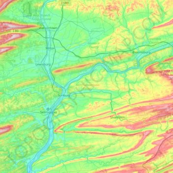
Name: Northumberland County topographic map, elevation, terrain.
Location: Northumberland County, Pennsylvania, United States (40.60363 -76.94820 41.17573 -76.38025)
Average elevation: 251 m
Minimum elevation: 115 m
Maximum elevation: 630 m
Other topographic maps
Click on a map to view its topography, its elevation and its terrain.
Williamsburg
United States > Pennsylvania > Armstrong County > East Franklin Township
Average elevation: 319 m
East Texas
United States > Pennsylvania > Lehigh County > Lower Macungie Township
Average elevation: 126 m
Dingmans Ferry
United States > Pennsylvania > Pike County > Delaware Township
Average elevation: 192 m
Blue Mountain
United States > Pennsylvania > Schuylkill County > Washington Township
The ridge of Blue Mountain runs for 150 miles (240 km) through Pennsylvania, reaching an elevation of 2,270 feet (690 m) above sea level just north of the Pennsylvania Turnpike, near the borough of Newburg. Most of the ridgecrest, however, only reaches between 1,400 and 1,700 feet (430 and 520 m) in elevation.…
Average elevation: 226 m
Allegheny River Lock and Dam No. 2
United States > Pennsylvania > Allegheny County > O'Hara Township
Average elevation: 268 m
Madisonville
United States > Pennsylvania > Lackawanna County > Madison Township
Average elevation: 512 m
Highland Park Reservoir No. 2
United States > Pennsylvania > Allegheny County > Pittsburgh
Average elevation: 275 m
Ashmead Village
United States > Pennsylvania > Montgomery County > Cheltenham Township > Cheltenham
Average elevation: 51 m
Stevens Point
United States > Pennsylvania > Susquehanna County > Harmony Township
Average elevation: 434 m
Pendle Hill
United States > Pennsylvania > Delaware County > Nether Providence Township
Average elevation: 61 m
Atlas
United States > Pennsylvania > Northumberland County > Mount Carmel Township
Average elevation: 385 m
Alverton
United States > Pennsylvania > Westmoreland County > East Huntingdon Township
Average elevation: 361 m
Saint Boniface
United States > Pennsylvania > Cambria County > Elder Township
Average elevation: 593 m
Sunset
United States > Pennsylvania > Lebanon County > North Lebanon Township
Average elevation: 180 m
Chestnut Crossroads
United States > Pennsylvania > Cumberland County > Southampton Township
Average elevation: 256 m
Southampton
United States > Pennsylvania > Bucks County > Upper Southampton Township
Average elevation: 75 m
Park Place
United States > Pennsylvania > Schuylkill County > Mahanoy Township
Average elevation: 515 m
Portlamd Waterfront Park
United States > Pennsylvania > Northampton County > Portland
Average elevation: 118 m
Blue Mountain
United States > Pennsylvania > Monroe County > Eldred Township
The ridge of Blue Mountain runs for 150 miles (240 km) through Pennsylvania, reaching an elevation of 2,270 feet (690 m) above sea level just north of the Pennsylvania Turnpike, near the borough of Newburg. Most of the ridgecrest, however, only reaches between 1,400 and 1,700 feet (430 and 520 m) in elevation.…
Average elevation: 242 m
Hamburg Reservoir
United States > Pennsylvania > Berks County > Windsor Township
Average elevation: 339 m
North Springfield
United States > Pennsylvania > Erie County > Springfield Township
Average elevation: 199 m
Fort Hunter
United States > Pennsylvania > Dauphin County > Middle Paxton Township
Average elevation: 149 m
Jeffersonville
United States > Pennsylvania > Montgomery County > West Norriton Township
Average elevation: 56 m
Grassmere Park
United States > Pennsylvania > Columbia County > Sugarloaf Township
Average elevation: 355 m
Elimsport
United States > Pennsylvania > Lycoming County > Washington Township
Average elevation: 192 m
Moorestown
United States > Pennsylvania > Northampton County > Moore Township
Average elevation: 219 m
Faylor Lake
United States > Pennsylvania > Snyder County > Spring Township > Beaver Springs
Average elevation: 197 m
Beaver Valley
United States > Pennsylvania > Cambria County > Clearfield Township
Average elevation: 492 m
Faylor Lake
United States > Pennsylvania > Snyder County > Spring Township > Beaver Springs
Average elevation: 197 m
East Waterford
United States > Pennsylvania > Juniata County > Tuscarora Township
Average elevation: 257 m
Hickory Run State Park
United States > Pennsylvania > Carbon County > Kidder Township
Average elevation: 471 m
Cove Mountain
United States > Pennsylvania > Lycoming County > Gamble Township
Average elevation: 426 m
Booths Corner
United States > Pennsylvania > Delaware County > Bethel Township
Average elevation: 105 m
Gladhill (Greenstone P.O.)
United States > Pennsylvania > Adams County > Hamiltonban Township
Average elevation: 365 m
Whitehorse
United States > Pennsylvania > Chester County > Willistown Township
Average elevation: 117 m
Bardwell
United States > Pennsylvania > Wyoming County > Tunkhannock Township
Average elevation: 297 m
East Nantmeal
United States > Pennsylvania > Chester County > East Nantmeal Township
Average elevation: 197 m
Pine Grove Furnace
United States > Pennsylvania > Cumberland County > Cooke Township
Average elevation: 332 m
Slate Lick
United States > Pennsylvania > Armstrong County > South Buffalo Township
Average elevation: 356 m
Chadds Ford
United States > Pennsylvania > Delaware County > Chadds Ford Township
Average elevation: 86 m
Southampton
United States > Pennsylvania > Bucks County > Upper Southampton Township
Average elevation: 75 m
Brandywine Village
United States > Pennsylvania > Montgomery County > Upper Merion Township
Average elevation: 50 m
Wapwallopen
United States > Pennsylvania > Luzerne County > Conyngham Township
Average elevation: 223 m
Welsh Mountain
United States > Pennsylvania > Lancaster County > Caernarvon Township
Average elevation: 233 m
Pastorius Park
United States > Pennsylvania > Philadelphia County > Philadelphia
Average elevation: 108 m
Gladwyne
United States > Pennsylvania > Montgomery County > Lower Merion Township
Average elevation: 92 m
Spring Plains
United States > Pennsylvania > York County > Springettsbury Township
Average elevation: 151 m
Buckeye
United States > Pennsylvania > Westmoreland County > East Huntingdon Township
Average elevation: 338 m
Martins Creek
United States > Pennsylvania > Northampton County > Lower Mount Bethel Township
Average elevation: 127 m
Beltzville State Park - Parking Lot B
United States > Pennsylvania > Carbon County > Lehighton
Average elevation: 222 m
Huntingdon Valley
United States > Pennsylvania > Montgomery County > Lower Moreland Township
Average elevation: 65 m
Huntington Mills
United States > Pennsylvania > Luzerne County > Huntington Township
Average elevation: 289 m
Reeceville
United States > Pennsylvania > Chester County > West Brandywine Township
Average elevation: 169 m
Gillett
United States > Pennsylvania > Bradford County > South Creek Township
Average elevation: 470 m