
Bushenyi topographic map
Interactive map
Click on the map to display elevation.
About this map
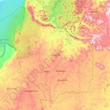
Name: Bushenyi topographic map, elevation, terrain.
Location: Bushenyi, Western Region, Uganda (-0.66409 29.90368 -0.29971 30.30979)
Average elevation: 1,496 m
Minimum elevation: 959 m
Maximum elevation: 2,022 m
Other topographic maps
Click on a map to view its topography, its elevation and its terrain.
Panduku
Panduku, Pawor, Madi Okollo, Northern Region, Uganda
Average elevation: 672 m
Muyembe
Uganda > Sironko > Bugisa sub-region
Muyembe, Bugisa sub-region, Sironko, Eastern Region, Uganda
Average elevation: 1,392 m
Village 5 Zone 1
Village 5 Zone 1, Udupi, Arua, Northern Region, Uganda
Average elevation: 746 m
Merikit Centre
Merikit Centre, Tororo, Eastern Region, Uganda
Average elevation: 1,119 m
Rubaare (nyarweshama)
Rubaare (nyarweshama), Sheema, Western Region, Uganda
Average elevation: 1,525 m
Ruhoko - Nyinendugu
Ruhoko - Nyinendugu, Ibanda, Western Region, Uganda
Average elevation: 1,416 m
Stage
Uganda > Bulambuli > Bugisa sub-region
Stage, Bugisa sub-region, Bulambuli, Eastern Region, Uganda
Average elevation: 1,792 m
Lower
Uganda > Western Region > Mbarara City
Lower, Mbarara City, Western Region, Uganda
Average elevation: 1,407 m
Rushebeya B
Rushebeya B, Kambuga Sub-County, Kanungu, Western Region, Uganda
Average elevation: 1,191 m