
Short Hills topographic map
Interactive map
Click on the map to display elevation.
About this map
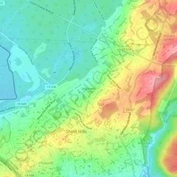
Name: Short Hills topographic map, elevation, terrain.
Average elevation: 98 m
Minimum elevation: 52 m
Maximum elevation: 173 m
Other topographic maps
Click on a map to view its topography, its elevation and its terrain.
Short Hills
United States > New Jersey > Essex County > Short Hills
Hartshorn chose the name "Short Hills" because it reflected the topography of the region, and also because the local Lenape Native Americans used that same name to describe the region. One local resident suggested that he call his village "Hartshornville," but he refused, quietly content with Short Hills…
Average elevation: 85 m