
Monroe County topographic map
Interactive map
Click on the map to display elevation.
Monroe County
According to the Trewartha climate classification system, the higher elevation Pocono Plateau Region of Monroe County has a Temperate Continental climate (Dc) with warm summers (b), cold winters (o) and year-around precipitation (Dcbo). Dcbo climates are characterized by at least one month having an average mean temperature ≤ 32.0 °F (0.0 °C), four to seven months with an average mean temperature ≥ 50.0 °F (10.0 °C), all months with an average mean temperature < 72.0 °F (22.2 °C) and no significant precipitation difference between seasons. Although most summer days are comfortably humid on the Pocono Plateau, episodes of heat and high humidity can occur with heat index values > 92 °F (33 °C). Since 1981, the highest air temperature was 93.0 °F (33.9 °C) on 07/15/1995, and the highest daily average mean dew point was 70.8 °F (21.6 °C) on 08/01/2006. July is the peak month for thunderstorm activity which correlates with the average warmest month of the year. Since 1981, the wettest calendar day was 6.43 inches (163 mm) on 09/30/2010. During the winter months, the plant hardiness zone is 5b with an average annual extreme minimum air temperature of −11.2 °F (−24.0 °C). Since 1981, the coldest air temperature was −22.9 °F (−30.5 °C) on 01/21/1994. Episodes of extreme cold and wind can occur with wind chill values < −24 °F (−31 °C). The average snowiest month is January which correlates with the average coldest month of the year. Ice storms and large snowstorms depositing ≥ 12 inches (30 cm) of snow occur nearly every year, particularly during nor’easters from December through March.
About this map
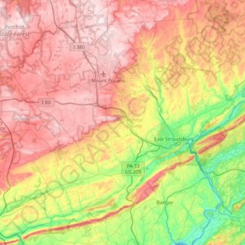
Name: Monroe County topographic map, elevation, terrain.
Location: Monroe County, Pennsylvania, United States (40.81484 -75.64929 41.25213 -74.96660)
Average elevation: 361 m
Minimum elevation: 56 m
Maximum elevation: 684 m
Other topographic maps
Click on a map to view its topography, its elevation and its terrain.
Dingmans Ferry
United States > Pennsylvania > Pike County > Delaware Township
Average elevation: 192 m
East Waterford
United States > Pennsylvania > Juniata County > Tuscarora Township
Average elevation: 257 m
Springtown
United States > Pennsylvania > Bucks County > Springfield Township
Average elevation: 163 m
East Texas
United States > Pennsylvania > Lehigh County > Lower Macungie Township
Average elevation: 126 m
Blue Mountain
United States > Pennsylvania > Schuylkill County > Washington Township
The ridge of Blue Mountain runs for 150 miles (240 km) through Pennsylvania, reaching an elevation of 2,270 feet (690 m) above sea level just north of the Pennsylvania Turnpike, near the borough of Newburg. Most of the ridgecrest, however, only reaches between 1,400 and 1,700 feet (430 and 520 m) in elevation.…
Average elevation: 226 m
Mauntain View Lake
United States > Pennsylvania > Dauphin County > Halifax Township
Average elevation: 207 m
Bartram's Garden
United States > Pennsylvania > Philadelphia County > Philadelphia
Average elevation: 13 m
Long Pond
United States > Pennsylvania > Monroe County > Tunkhannock Township
Long Pond is named after the wetland topography formed by Tunkhannock Creek. Within the Long Pond community are public access lands, containing many species of plants and animals. Long Pond has been called "the most unique inland freshwater wetland in the state".
Average elevation: 571 m
Rydal Park
United States > Pennsylvania > Montgomery County > Abington Township
Average elevation: 87 m
McGovernsville
United States > Pennsylvania > Lancaster County > East Hempfield Township > Rohrerstown
Average elevation: 109 m
Holiday Poconos
United States > Pennsylvania > Carbon County > Kidder Township
Average elevation: 519 m
Intercourse
United States > Pennsylvania > Lancaster County > Leacock Township
Average elevation: 127 m
Tyler State Park
United States > Pennsylvania > Bucks County > Northampton Township
Average elevation: 67 m
Canoe Creek
United States > Pennsylvania > Blair County > Frankstown Township
Average elevation: 347 m
Loyalsockville
United States > Pennsylvania > Lycoming County > Upper Fairfield Township
Average elevation: 262 m
Plumsteadville
United States > Pennsylvania > Bucks County > Plumstead Township
Average elevation: 160 m
Pocono Lake
United States > Pennsylvania > Monroe County > Tobyhanna Township
Average elevation: 543 m
Strickhousers
United States > Pennsylvania > York County > North Codorus Township
Average elevation: 205 m
Loch Lomond Junction
United States > Pennsylvania > Centre County > Rush Township
Average elevation: 460 m
Gwynedd Valley
United States > Pennsylvania > Montgomery County > Lower Gwynedd Township
Average elevation: 93 m
Farmdale
United States > Pennsylvania > Lancaster County > West Hempfield Township
Average elevation: 131 m
Central Highlands
United States > Pennsylvania > Allegheny County > Elizabeth Township
Average elevation: 327 m
Schollard
United States > Pennsylvania > Mercer County > Springfield Township > Leesburg
Average elevation: 379 m
Teepleville
United States > Pennsylvania > Crawford County > Richmond Township
Average elevation: 386 m
Welsh Mountain Nature Preserve
United States > Pennsylvania > Lancaster County > East Earl Township
Average elevation: 294 m
Mechanicsville
United States > Pennsylvania > Bucks County > Buckingham Township
Average elevation: 117 m
Raven Rock Mountain
United States > Pennsylvania > Adams County > Liberty Township
Average elevation: 312 m
Ironton
United States > Pennsylvania > Lehigh County > North Whitehall Township
Average elevation: 158 m
Sagamore Estates
United States > Pennsylvania > Pike County > Shohola Township
Average elevation: 412 m
Tire Hill
United States > Pennsylvania > Somerset County > Conemaugh Township
Average elevation: 466 m
Mont Clare
United States > Pennsylvania > Montgomery County > Upper Providence Township
Average elevation: 56 m
Frills Corners
United States > Pennsylvania > Clarion County > Washington Township
Average elevation: 482 m
East Springfield
United States > Pennsylvania > Erie County > Springfield Township
Average elevation: 229 m
Turkeytown
United States > Pennsylvania > Westmoreland County > South Huntingdon Township
Average elevation: 317 m
Maple Grove Park
United States > Pennsylvania > Berks County > Brecknock Township
Average elevation: 198 m
Blue Ridge Summit
United States > Pennsylvania > Franklin County > Washington Township
Pennsylvania Route 16 passes through Blue Ridge Summit, leading east down the mountain to Emmitsburg, Maryland, and west downhill to Waynesboro. The highway elevation at Blue Ridge Summit is 1,330 feet (410 m), compared to elevations of 500 and 700 feet (150 and 210 m) east and west of the mountain,…
Average elevation: 400 m
Coraopolis Heights
United States > Pennsylvania > Allegheny County > Findlay Township
Average elevation: 320 m
Valley Forge
United States > Pennsylvania > Chester County > Schuylkill Township
Average elevation: 78 m
Chaneysville
United States > Pennsylvania > Bedford County > Southampton Township
Average elevation: 373 m
Andreas
United States > Pennsylvania > Schuylkill County > West Penn Township
Average elevation: 250 m
Copesville
United States > Pennsylvania > Chester County > East Bradford Township
Average elevation: 92 m
Smithville
United States > Pennsylvania > Lancaster County > Providence Township
Average elevation: 140 m
Leather Corner Post
United States > Pennsylvania > Lehigh County > Lowhill Township
Average elevation: 178 m
Pine Hill Vista
United States > Pennsylvania > Lackawanna County > Thornhurst Township
Average elevation: 628 m
Landisville
United States > Pennsylvania > Bucks County > Buckingham Township
Average elevation: 121 m
Wrightstown
United States > Pennsylvania > Bucks County > Wrightstown Township
Average elevation: 85 m
United
United States > Pennsylvania > Westmoreland County > Mount Pleasant Township
Average elevation: 326 m
Stiefler Corner
United States > Pennsylvania > Bedford County > Kimmel Township
Average elevation: 520 m
East Passyunk Community Recreation Center
United States > Pennsylvania > Philadelphia County > Philadelphia
Average elevation: 9 m