
Central City topographic map
Interactive map
Click on the map to display elevation.
About this map
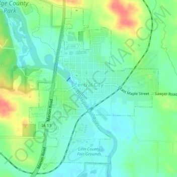
Name: Central City topographic map, elevation, terrain.
Location: Central City, Linn County, Iowa, United States (42.19101 -91.53663 42.21577 -91.51001)
Average elevation: 265 m
Minimum elevation: 246 m
Maximum elevation: 304 m
Other topographic maps
Click on a map to view its topography, its elevation and its terrain.
Cedar Rapids
United States > Iowa > Linn County
Cedar Rapids, Linn County, Iowa, United States
Average elevation: 245 m
Springville
United States > Iowa > Linn County
Springville, Linn County, Iowa, 52336, United States
Average elevation: 265 m
Paris
United States > Iowa > Linn County
Paris, Linn County, Iowa, 52218, United States
Average elevation: 269 m
Fairfax
United States > Iowa > Linn County
Fairfax, Linn County, Iowa, United States
Average elevation: 239 m
Palo
United States > Iowa > Linn County > Palo
Palo, Linn County, Iowa, United States
Average elevation: 229 m