
نبر topographic map
Interactive map
Click on the map to display elevation.
About this map
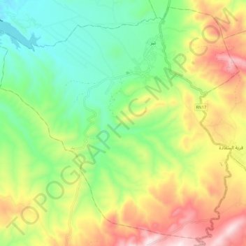
Name: نبر topographic map, elevation, terrain.
Location: نبر, Nibbar, Al Kaf, Tunisia (36.23845 8.70413 36.31714 8.80772)
Average elevation: 509 m
Minimum elevation: 241 m
Maximum elevation: 911 m
Other topographic maps
Click on a map to view its topography, its elevation and its terrain.
الكاف
Tunisia > Al Kaf > وادي الرمل الجنوبية
الكاف, وادي الرمل الجنوبية, معتمدية الكاف الغربية, Al Kaf, Tunisia
Average elevation: 466 m