
Värmdö kommun topographic map
Interactive map
Click on the map to display elevation.
About this map
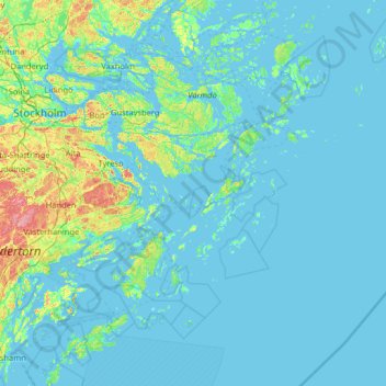
Name: Värmdö kommun topographic map, elevation, terrain.
Location: Värmdö kommun, Stockholm County, Sweden (58.85711 18.31927 59.51576 19.59269)
Average elevation: 9 m
Minimum elevation: -3 m
Maximum elevation: 99 m
Other topographic maps
Click on a map to view its topography, its elevation and its terrain.
Södertälje
Prior to 600 AD, the lake Mälaren was connected to the sea. Due to land elevation, the lake was slowly cut off, and boats had to be dragged over land to and from the lake. This demanded labour, who settled in a village here.
Average elevation: 38 m
Södertälje
Due to its topography and the fact that it is divided by a canal, it has been difficult to build good train connections in and through the city. Despite this, Södertälje is one of the largest railway hubs in Sweden. When the railway to Södertälje was commissioned, it was decided that the main line would…
Average elevation: 32 m