
จังหวัดพระนครศรีอยุธยา topographic map
Interactive map
Click on the map to display elevation.
About this map
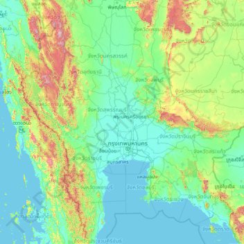
Name: จังหวัดพระนครศรีอยุธยา topographic map, elevation, terrain.
Location: จังหวัดพระนครศรีอยุธยา, Thailand (11.73807 97.81546 16.85807 102.93546)
Average elevation: 184 m
Minimum elevation: -2 m
Maximum elevation: 2,024 m
Other topographic maps
Click on a map to view its topography, its elevation and its terrain.
ตำบลท่าวาสุกรี
Thailand > จังหวัดพระนครศรีอยุธยา > ตำบลท่าวาสุกรี
ตำบลท่าวาสุกรี, เทศบาลนครพระนครศรีอยุธยา, อำเภอพระนครศรีอยุธยา, จังหวัดพระนครศรีอยุธยา, 13000, Thailand
Average elevation: 7 m
Phra Nakhon Si Ayutthaya
Thailand > จังหวัดพระนครศรีอยุธยา > Phra Nakhon Si Ayutthaya
Phra Nakhon Si Ayutthaya, จังหวัดพระนครศรีอยุธยา, 13000, Thailand
Average elevation: 5 m