
Blatten topographic map
Interactive map
Click on the map to display elevation.
About this map
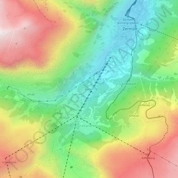
Name: Blatten topographic map, elevation, terrain.
Location: Blatten, Zermatt, Visp, Wallis, 3920, Switzerland (45.98762 7.71604 46.02762 7.75604)
Average elevation: 2,149 m
Minimum elevation: 1,595 m
Maximum elevation: 2,889 m
Other topographic maps
Click on a map to view its topography, its elevation and its terrain.
Matterhorn
Switzerland > Wallis > Visp > Zermatt
Matterhorn, Zermatt, Visp, Wallis, 3920, Switzerland
Average elevation: 3,295 m
Monte Rosa
Switzerland > Wallis > Visp > Zermatt
Monte Rosa, Zermatt, Visp, Wallis, 3920, Switzerland
Average elevation: 4,033 m
Gornera
Switzerland > Wallis > Visp > Zermatt
Gornera, Zermatt, Visp, Wallis, 3920, Switzerland
Average elevation: 2,226 m