
Goshen topographic map
Interactive map
Click on the map to display elevation.
About this map
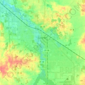
Name: Goshen topographic map, elevation, terrain.
Location: Goshen, Elkhart County, Indiana, United States (41.52251 -85.91654 41.62971 -85.77057)
Average elevation: 252 m
Minimum elevation: 232 m
Maximum elevation: 283 m
Other topographic maps
Click on a map to view its topography, its elevation and its terrain.
Elkhart
United States > Indiana > Elkhart County
Elkhart, Elkhart County, Indiana, United States
Average elevation: 235 m
Middlebury
United States > Indiana > Elkhart County
Middlebury, Elkhart County, Indiana, United States
Average elevation: 266 m
Wakarusa
United States > Indiana > Elkhart County
Wakarusa, Elkhart County, Indiana, 46573, United States
Average elevation: 257 m