
Moroni topographic map
Interactive map
Click on the map to display elevation.
About this map
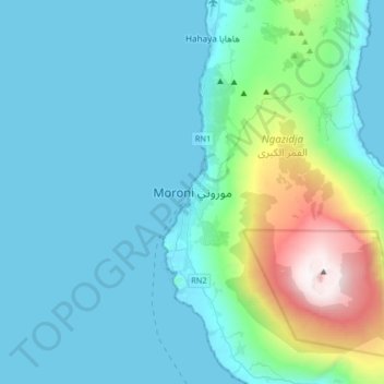
Name: Moroni topographic map, elevation, terrain.
Location: Moroni, Grande Comore, Comoros (-11.85313 43.09430 -11.53313 43.41430)
Average elevation: 351 m
Minimum elevation: 0 m
Maximum elevation: 2,354 m
The country's civil aviation authority, Ministère des Postes et Télécommunications de la Promotion des Nouvelles Technologies de l'Information et de la Communication chargé des Transports et du Tourisme, is located in Moroni, as is the National Agency of Civil Aviation and Meteorology. Moroni is served by the Prince Said Ibrahim International Airport, located at Hahaya, about 15 km (9 mi) north of the town. However, there are no direct flights to Europe. It is a civilian airport at an elevation of 28 m (92 ft) and has a paved runway which has dimensions of 2,900 by 45 metres (9,514 ft × 148 ft). Airlines which operate international flights to this airport are Air Tanzania, Air Austral and Kenya Airways. However, between the islands the local airlines, Int'Air Iles and AB Aviation operate.
Other topographic maps
Click on a map to view its topography, its elevation and its terrain.
Mount Karthala
Comoros > Grande Comore > Moroni
Mount Karthala, Moroni, Grande Comore, Comoros
Average elevation: 2,248 m