
Bengkulu topographic map
Interactive map
Click on the map to display elevation.
About this map
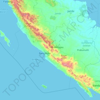
Name: Bengkulu topographic map, elevation, terrain.
Location: Bengkulu, Indonesia (-6.07868 99.97598 -0.95868 105.09598)
Average elevation: 146 m
Minimum elevation: -1 m
Maximum elevation: 3,657 m
Other topographic maps
Click on a map to view its topography, its elevation and its terrain.
Pulau Enggano
Indonesia > Bengkulu > Bengkulu Utara
Enggano (from Portuguese engano "mistake") is about 29 kilometres (18 miles) long from east to west and about 14 kilometres (8.7 miles) wide from north to south. Its area is 400.6 square kilometres (154.7 square miles) including four small offshore islands around its coast - Pulau Merbau, Pulau Dua and tiny…
Average elevation: 19 m