Geolocate

Laholms kommun topographic map

Interactive map

Click on the map to display elevation.

About this map

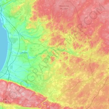
Name: Laholms kommun topographic map, elevation, terrain.

Location: Laholms kommun, Halland County, Sweden (56.32412 12.79733 56.68811 13.46728)

Average elevation: 98 m

Minimum elevation: -1 m

Maximum elevation: 224 m

Other topographic maps

Click on a map to view its topography, its elevation and its terrain.

Vendelsö

Sweden > Halland County

Average elevation: 2 m

Yllevad

Sweden > Halland County

Average elevation: 84 m

Olofsbo

Sweden > Halland County

Average elevation: 5 m

Stättared

Sweden > Halland County

Average elevation: 65 m

Foss

Sweden > Halland County > Rydöbruk

Average elevation: 113 m

Vindrarp

Sweden > Halland County

Average elevation: 86 m

Åled

Sweden > Halland County

Average elevation: 53 m

Skällinge

Sweden > Halland County

Average elevation: 68 m

Våxtorp

Sweden > Halland County

Average elevation: 45 m

Mästocka

Sweden > Halland County

Average elevation: 132 m

Halmstad

Sweden > Halland County

Average elevation: 38 m

Drängsered

Sweden > Halland County

Average elevation: 140 m

Plingshult

Sweden > Halland County

Average elevation: 141 m

Tjolöholms slott

Sweden > Halland County

Average elevation: 3 m

Kvibille

Sweden > Halland County

Average elevation: 52 m

Varberg

Sweden > Halland County

Average elevation: 8 m