
Fort Sill topographic map
Interactive map
Click on the map to display elevation.
About this map
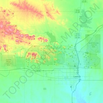
Name: Fort Sill topographic map, elevation, terrain.
Location: Fort Sill, Comanche County, Oklahoma, United States (34.63753 -98.75591 34.76803 -98.28239)
Average elevation: 417 m
Minimum elevation: 314 m
Maximum elevation: 749 m
Other topographic maps
Click on a map to view its topography, its elevation and its terrain.
Daly Hill
United States > Oklahoma > Comanche County
Daly Hill, Comanche County, Oklahoma, United States
Average elevation: 396 m
Jackson Hole
United States > Oklahoma > Comanche County
Jackson Hole, Comanche County, Oklahoma, United States
Average elevation: 406 m
South East Corner Landing Strip
United States > Oklahoma > Comanche County
South East Corner Landing Strip, Comanche County, Oklahoma, United States
Average elevation: 383 m
Mount McKinley
United States > Oklahoma > Comanche County
Mount McKinley, Comanche County, Oklahoma, United States
Average elevation: 498 m
Medicine Park
United States > Oklahoma > Comanche County > Medicine Park
Medicine Park, Comanche County, Oklahoma, 73557, United States
Average elevation: 429 m
Lawton
United States > Oklahoma > Comanche County
Lawton, Comanche County, Oklahoma, United States
Average elevation: 352 m