
Pinar del Rio topographic map
Interactive map
Click on the map to display elevation.
Pinar del Rio
The Pinar del Río province is Cuba's westernmost province and contains one of Cuba's three main mountain ranges, the Cordillera de Guaniguanico, divided into the easterly Sierra del Rosario and the westerly Sierra de los Órganos. These form a landscape characterised by steep sided limestone hills (called mogotes) and flat, fertile valleys. One such topographic feature, the Viñales Valley, is a UNESCO World Heritage Site.
About this map
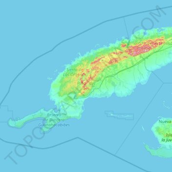
Name: Pinar del Rio topographic map, elevation, terrain.
Location: Pinar del Rio, Cuba (21.46914 -85.16797 23.14697 -82.92608)
Average elevation: 15 m
Minimum elevation: -2 m
Maximum elevation: 648 m
Other topographic maps
Click on a map to view its topography, its elevation and its terrain.
Cuatro Esquinas de Santa Lucía
Cuba > Sancti Spiritus > Noel Sancho > Cuatro Esquinas de Santa Lucía
Average elevation: 143 m