
Alexandria topographic map
Interactive map
Click on the map to display elevation.
About this map
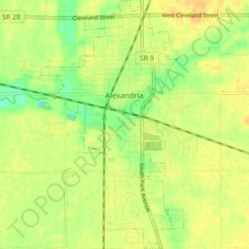
Name: Alexandria topographic map, elevation, terrain.
Location: Alexandria, Madison County, Indiana, 46001, United States (40.23399 -85.69635 40.28065 -85.66118)
Average elevation: 268 m
Minimum elevation: 251 m
Maximum elevation: 278 m
Other topographic maps
Click on a map to view its topography, its elevation and its terrain.
Elwood
United States > Indiana > Madison County
Elwood, Madison County, Indiana, 46036, United States
Average elevation: 264 m
Hillcrest
United States > Indiana > Madison County > Anderson
Hillcrest, Anderson, Madison County, Indiana, 46016, United States
Average elevation: 269 m
Mounds State Park
United States > Indiana > Madison County > Anderson
Mounds State Park, Anderson, Madison County, Indiana, United States
Average elevation: 276 m
Frankton
United States > Indiana > Madison County > Frankton
Frankton, Madison County, Indiana, United States
Average elevation: 259 m