
Medan Johor topographic map
Interactive map
Click on the map to display elevation.
About this map
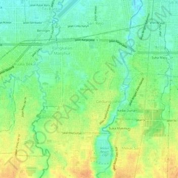
Name: Medan Johor topographic map, elevation, terrain.
Location: Medan Johor, City of Medan, North Sumatra, 20144, Indonesia (3.50784 98.64256 3.54720 98.69458)
Average elevation: 41 m
Minimum elevation: 26 m
Maximum elevation: 59 m
Other topographic maps
Click on a map to view its topography, its elevation and its terrain.
Medan Tembung
Indonesia > North Sumatra > City of Medan
Medan Tembung, City of Medan, North Sumatra, Indonesia
Average elevation: 19 m
Medan Polonia
Indonesia > North Sumatra > City of Medan
Medan Polonia, City of Medan, North Sumatra, Indonesia
Average elevation: 31 m
Glugur Darat I
Indonesia > North Sumatra > City of Medan > Glugur Darat I
Glugur Darat I, Medan Barat, City of Medan, North Sumatra, 20116, Indonesia
Average elevation: 16 m