
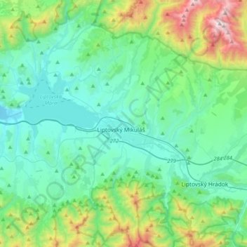
Liptovský Mikuláš topographic map
Interactive map
Click on the map to display elevation.
About this map
Name: Liptovský Mikuláš topographic map, elevation, terrain.
Average elevation: 852 m
Minimum elevation: 515 m
Maximum elevation: 2,163 m
Petra Vlhová, born and raised in the city, won the alpine skiing slalom gold medal at the 2022 Winter Olympics. As a child she attended many training at a ski center at Podbreziny hill of the city. Martina Dubovská also trained at the center in her childhood. The ski center at Podbreziny was established in 1993 and was discontinued gradually in early 2010s. In 2022, it was restored and re-entered into usage. The tracks combine to a total length of 550 meters at peak altitude of 700 meters.
Other topographic maps
Click on a map to view its topography, its elevation and its terrain.
Bobrovec
Slovakia > Region of Žilina > District of Liptovský Mikuláš > Bobrovec
Bobrovec, District of Liptovský Mikuláš, Region of Žilina, Central Slovakia, Slovakia
Average elevation: 1,013 m
Liptovské Matiašovce
Slovakia > Region of Žilina > District of Liptovský Mikuláš > Liptovské Matiašovce
Liptovské Matiašovce, District of Liptovský Mikuláš, Region of Žilina, Central Slovakia, Slovakia
Average elevation: 730 m