
Saluda topographic map
Interactive map
Click on the map to display elevation.
About this map
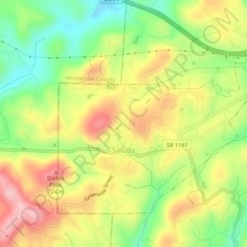
Name: Saluda topographic map, elevation, terrain.
Location: Saluda, Polk County, North Carolina, 28773, United States (35.22812 -82.36302 35.25086 -82.32559)
Average elevation: 635 m
Minimum elevation: 498 m
Maximum elevation: 735 m
Saluda is located in southwestern Polk County at 35°14′16″N 82°20′49″W / 35.237856°N 82.346870°W / 35.237856; -82.346870 (35.237856, -82.346870). Two small parts of the city extend west and north into Henderson County. The elevation on Main Street is 2,097 feet (639 m) above sea level, while the elevation at the bottom end of the Saluda Grade, in Tryon, is 1,080 feet (329.1 m).
Other topographic maps
Click on a map to view its topography, its elevation and its terrain.
Peniel
United States > North Carolina > Polk County
Peniel, Polk County, North Carolina, 28722, United States
Average elevation: 326 m
Tryon
United States > North Carolina > Polk County
Tryon, Polk County, North Carolina, United States
Average elevation: 333 m
Howard Gap
United States > North Carolina > Polk County
Howard Gap, Polk County, North Carolina, United States
Average elevation: 573 m