
Graceville topographic map
Interactive map
Click on the map to display elevation.
About this map
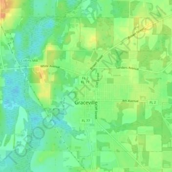
Name: Graceville topographic map, elevation, terrain.
Location: Graceville, Jackson County, Florida, United States (30.94497 -85.53256 30.97573 -85.48852)
Average elevation: 48 m
Minimum elevation: 32 m
Maximum elevation: 69 m
Jackson County is a rural community primarily composed of business in agriculture, manufacturing, service, and retail trade. In addition, many government facilities are located within the county, including a federal prison and three state correctional institutions. Elevation ranges from 50 to 330 feet (100 m) above sea level. Marianna is 185 feet (56 m) above sea level.