
Leixlip topographic map
Interactive map
Click on the map to display elevation.
About this map
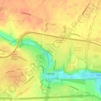
Name: Leixlip topographic map, elevation, terrain.
Average elevation: 53 m
Minimum elevation: 23 m
Maximum elevation: 68 m
British publisher and cartographer Samuel Lewis mentions Confey Castle in the first volume of his 1837 work A Topographical Dictionary of Ireland. In it, he comments that Confey's (or Confoy as he spells it) population was 165, had formerly had a town and a castle of some importance, which were noticed by Camden. Of the tower's remains were a massive five-storey structure with turrets at the north and west angles; that at the north angle containing a winding staircase opening through pointed arches into each storey. The principal entrance was under a semicircular archway. In the war of 1688 the castle is said to have been strongly garrisoned, and to have sustained an attack.[23]
Other topographic maps
Click on a map to view its topography, its elevation and its terrain.
Grand Canal - Barrow Line
Ireland > County Kildare > Athy
Grand Canal - Barrow Line, Athy, Athy Urban West ED, The Municipal District of Athy, County Kildare, Leinster, R14 EH50, Ireland
Average elevation: 60 m
Allenwood
Allenwood, The Municipal District of Clane — Maynooth, County Kildare, Leinster, W91 XW6H, Ireland
Average elevation: 82 m
Newbridge
Newbridge, The Municipal District of Kildare — Newbridge, County Kildare, Leinster, Ireland
Average elevation: 95 m
Sallins
Sallins, The Municipal District of Naas, County Kildare, Leinster, Ireland
Average elevation: 81 m
Ballysax
Ballysax, The Municipal District of Kildare — Newbridge, County Kildare, Leinster, Ireland
Average elevation: 107 m
Kilkea Upper
Kilkea Upper, Kilkea ED, The Municipal District of Athy, County Kildare, Leinster, Ireland
Average elevation: 82 m
Carbury
Carbury, The Municipal District of Clane — Maynooth, County Kildare, Leinster, W91 K763, Ireland
Average elevation: 90 m
Castledermot
Castledermot, Abbeylands, Castledermot ED, The Municipal District of Athy, County Kildare, Leinster, Ireland
Average elevation: 83 m
Clane
Clane, Alexandra Walk, Clane ED, The Municipal District of Clane — Maynooth, County Kildare, Leinster, Ireland
Average elevation: 70 m
The Municipal District of Athy
The Municipal District of Athy, County Kildare, Leinster, Ireland
Average elevation: 101 m
Straffan
Ireland > County Kildare > Straffan
Straffan, The Municipal District of Clane — Maynooth, County Kildare, Leinster, W23 V628, Ireland
Average elevation: 65 m
Athy
Athy, Athy Urban East ED, The Municipal District of Athy, County Kildare, Leinster, R14 XD30, Ireland
Average elevation: 61 m
The Municipal District of Clane — Maynooth
The Municipal District of Clane — Maynooth, County Kildare, Leinster, Ireland
Average elevation: 86 m
Rathangan
Ireland > County Kildare > Rathangan
Rathangan, County Kildare, Leinster, Ireland
Average elevation: 76 m
Ballyteague Bog
Ballyteague Bog, Rathernan ED, The Municipal District of Kildare — Newbridge, County Kildare, Leinster, Ireland
Average elevation: 77 m
Clane
Ireland > County Kildare > Clane
Clane, The Municipal District of Clane — Maynooth, County Kildare, Leinster, W91 X253, Ireland
Average elevation: 78 m
The Municipal District of Kildare — Newbridge
The Municipal District of Kildare — Newbridge, County Kildare, Leinster, Ireland
Average elevation: 93 m
The Municipal District of Naas
The Municipal District of Naas, County Kildare, Leinster, Ireland
Average elevation: 152 m
Castledermot
Ireland > County Kildare > Castledermot
Castledermot, The Municipal District of Athy, County Kildare, Leinster, Ireland
Average elevation: 94 m