Geolocate

Giles Conrad Park topographic map

Interactive map

Click on the map to display elevation.

About this map

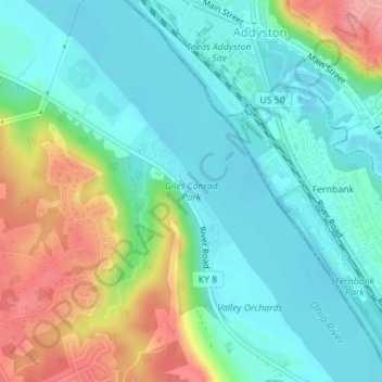
Name: Giles Conrad Park topographic map, elevation, terrain.

Location: Giles Conrad Park, Boone County, Kentucky, United States of America (39.12070 -84.72131 39.13026 -84.71147)

Average elevation: 172 m

Minimum elevation: 138 m

Maximum elevation: 250 m

Other topographic maps

Click on a map to view its topography, its elevation and its terrain.

Ludlow

United States of America > Kentucky > Ludlow

Average elevation: 182 m

Ashbrook

United States of America > Kentucky > Ashbrook

Average elevation: 239 m

Lovely

United States of America > Kentucky > Lovely

Average elevation: 266 m

Honeybee

United States of America > Kentucky > Honeybee

Average elevation: 337 m

Clifty

United States of America > Kentucky > Clifty

Average elevation: 225 m

Marydale

United States of America > Kentucky > Marydale

Average elevation: 267 m

Fulton

United States of America > Kentucky > Fulton

Average elevation: 124 m

Ellwood

United States of America > Kentucky > Ellwood

Average elevation: 375 m