
Mykolaiv topographic map
Interactive map
Click on the map to display elevation.
Mykolaiv
Mykolaiv is in a primarily flat terrain area (the steppe grain-producing region of southern Ukraine). The nearest mountains to Mykolaiv are 300 kilometres (186 miles) south, at the southern end of the Crimean Peninsula. The lack of any mountain barriers north of Mykolaiv means that very cold Arctic winds can blow south, unimpeded by any terrain elevation, to Mykolaiv in winter.
About this map
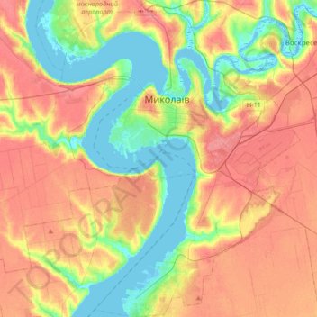
Name: Mykolaiv topographic map, elevation, terrain.
Average elevation: 32 m
Minimum elevation: -6 m
Maximum elevation: 64 m