
Yerba Buena Island topographic map
Interactive map
Click on the map to display elevation.
About this map
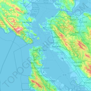
Name: Yerba Buena Island topographic map, elevation, terrain.
Average elevation: 70 m
Minimum elevation: -5 m
Maximum elevation: 778 m
Other topographic maps
Click on a map to view its topography, its elevation and its terrain.
Golden Gate Park
United States > California > San Francisco
In the 1860s, San Franciscans began to feel the need for a spacious public park similar to Central Park, which was then taking shape in New York City. Golden Gate Park was carved out of unpromising sand and shore dunes that were known as the Outside Lands, in an unincorporated area west of San Francisco's…
Average elevation: 71 m
Alcatraz Island
United States > California > San Francisco
Alcatraz Island view from the west. Image shot from an altitude of approximately 1,800 ft (549 m).
Average elevation: 0 m