Geolocate

Ntungwe topographic map

Interactive map

Click on the map to display elevation.

About this map

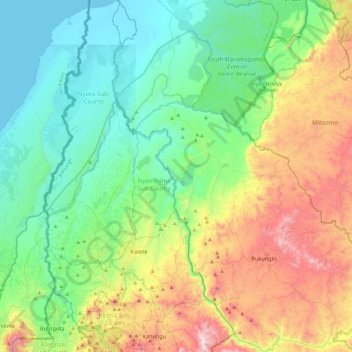
Name: Ntungwe topographic map, elevation, terrain.

Location: Ntungwe, Rukungiri, Western Region, Uganda (-0.91823 29.71817 -0.43954 30.05306)

Average elevation: 1,236 m

Minimum elevation: 912 m

Maximum elevation: 2,007 m

Other topographic maps

Click on a map to view its topography, its elevation and its terrain.

Rwekigyera

Uganda > Rukungiri

Rwekigyera, Rukungiri, Western Region, Uganda

Average elevation: 1,557 m

Nyakabungo

Uganda > Rukungiri

Nyakabungo, Rukungiri, Western Region, Uganda

Average elevation: 1,495 m

Rwerere

Uganda > Rukungiri > Rwerere

Rwerere, Rukungiri, Western Region, Uganda

Average elevation: 1,442 m

Nyabitete

Uganda > Rukungiri > Nyabitete

Nyabitete, Rukungiri, Western Region, Uganda

Average elevation: 1,555 m