
Stoke Holy Cross topographic map
Interactive map
Click on the map to display elevation.
About this map
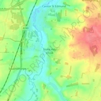
Name: Stoke Holy Cross topographic map, elevation, terrain.
Average elevation: 32 m
Minimum elevation: 3 m
Maximum elevation: 72 m
Norfolk trails, hiking, mountain biking, running and outdoor activities
Other topographic maps
Click on a map to view its topography, its elevation and its terrain.
Fundenhall
United Kingdom > England > Norfolk > South Norfolk > Ashwellthorpe and Fundenhall
Average elevation: 50 m
Poringland Wood
United Kingdom > England > Norfolk > South Norfolk > Framingham Earl
Average elevation: 50 m
Tivetshall St Mary
United Kingdom > England > Norfolk > South Norfolk > Tivetshall St Mary
Average elevation: 46 m
Beckhithe
United Kingdom > England > Norfolk > South Norfolk > Little Melton > Beckhithe
Average elevation: 37 m