Geolocate

Luton topographic map

Click on the map to display elevation.

About this map

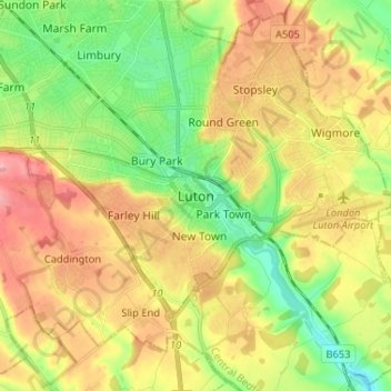
Name: Luton topographic map, elevation, terrain.

Location: Luton, Borough of Luton, England, LU1 2YN, United Kingdom (51.83844 -0.45528 51.91844 -0.37528)

Average elevation: 145 m

Minimum elevation: 91 m

Maximum elevation: 208 m

Borough of Luton trails, hiking, mountain biking, running and outdoor activities

Other topographic maps

Click on a map to view its topography, its elevation and its terrain.

Wardown Park

United Kingdom > England > Borough of Luton > Luton

Average elevation: 131 m

Luton

United Kingdom > England > Borough of Luton > Luton

Average elevation: 148 m

Gear up for your next adventure:

🍲Portable Camping Stoves - Fast-boiling stoves for hot meals on remote topographic survey trips
🧷Tenacious Repair Tape - Instant fix for torn tents, jackets, or dry bags
🗺️Ordnance Survey Maps - Official UK maps for walking and outdoor activities
🧴Tick Removal Tools - Small, essential health tool for UK woodland and moorland
Lightweight Solo Tents - Backpacking tents designed for wild camping in the UK highlands

As an Amazon Associate, this site earns from qualifying purchases at no extra cost to you.