
São Joaquim topographic map
Interactive map
Click on the map to display elevation.
São Joaquim
According to data from the National Institute of Meteorology (INMET), from 1961 to 1983, 1988 to 1989, 1992 to 1998 and from 2000 to 2017, the lowest temperature recorded in São Joaquim (conventional station) was 15.8 °F (-9 °C) in July 14, 2000. Since 1961 there have been 10 times where the minimum temperatures reached 19.4 °F (-7 °C) or less. For the same period until October 10, 2018 were 435 times when the temperature was at 30.2 °F (-1 °C) or less below zero at 57 years. The highest reached 88.5 °F (31.4 °C) on December 20, 1971. Temperature records above 86 °F (30 °C) also occurred on December 19, 1971 (87.8 °F or 31 °C), January 4, 1963 (87.1 °F or 30.6 °C), January 6, 1963 (86.7 °F or 30.4 °C), February 1973 (86.2 °F or 30.1 °C) and 17 December 1995 (86 °F or 30 °C). All in just 4 occasions the temperature has surpassed 86 °F (30 °C) since 1961, which is rare for a city in the 28th parallel or even for elevation. On July 13, 2000, the temperature did not exceed 28.4 °F (-2 °C), which was the lowest recorded in the period.
About this map
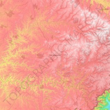
Name: São Joaquim topographic map, elevation, terrain.
Average elevation: 1,187 m
Minimum elevation: 133 m
Maximum elevation: 1,762 m
Other topographic maps
Click on a map to view its topography, its elevation and its terrain.