
Manchester Township topographic map
Interactive map
Click on the map to display elevation.
About this map
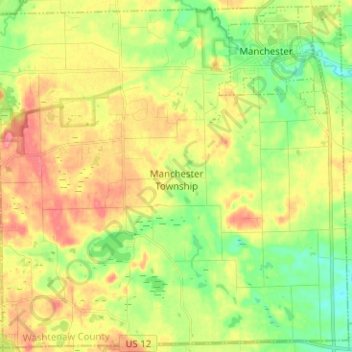
Name: Manchester Township topographic map, elevation, terrain.
Average elevation: 292 m
Minimum elevation: 256 m
Maximum elevation: 332 m
Other topographic maps
Click on a map to view its topography, its elevation and its terrain.
Rawsonville
United States > Michigan > Washtenaw County > Ypsilanti Charter Township
Average elevation: 214 m
Rawsonville
United States > Michigan > Washtenaw County > Ypsilanti Charter Township
Average elevation: 214 m
Mooreville
United States > Michigan > Washtenaw County > York Charter Township
Average elevation: 222 m