
Ouseburn topographic map
Interactive map
Click on the map to display elevation.
About this map
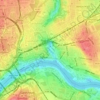
Name: Ouseburn topographic map, elevation, terrain.
Average elevation: 37 m
Minimum elevation: -1 m
Maximum elevation: 68 m
Other topographic maps
Click on a map to view its topography, its elevation and its terrain.
Quarry Park
United Kingdom > England > Tyne and Wear > Newcastle upon Tyne
Quarry Park, South Gosforth, Newcastle upon Tyne, Tyne and Wear, North East England, England, United Kingdom
Average elevation: 60 m
Leazes Park
United Kingdom > England > Tyne and Wear > Newcastle upon Tyne
Leazes Park, Spital Tongues, Newcastle upon Tyne, Tyne and Wear, North East England, England, NE2 4BJ, United Kingdom
Average elevation: 71 m
Hunters Moor
United Kingdom > England > Tyne and Wear > Newcastle upon Tyne
Hunters Moor, Spital Tongues, Newcastle upon Tyne, Tyne and Wear, North East England, England, United Kingdom
Average elevation: 89 m