
Regional Unit of Boeotia topographic map
Interactive map
Click on the map to display elevation.
About this map
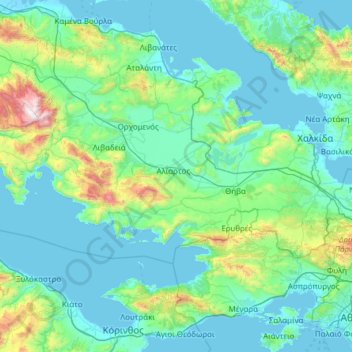
Name: Regional Unit of Boeotia topographic map, elevation, terrain.
Average elevation: 262 m
Minimum elevation: -2 m
Maximum elevation: 2,370 m
Other topographic maps
Click on a map to view its topography, its elevation and its terrain.
Farsala
Greece > Thessaly - Central Greece > Farsala
The Pharsalos of the historic era was built over a hillside of the Narthacius mountains at an elevation of some 160 m, where modern Farsala stands. It was one of the main cities in Thessaly and was the capital of the Phthian tetrarch. It was also a polis (city-state).
Average elevation: 215 m