
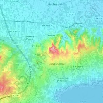
Rojales topographic map
Interactive map
Click on the map to display elevation.
About this map
Name: Rojales topographic map, elevation, terrain.
Average elevation: 24 m
Minimum elevation: -6 m
Maximum elevation: 121 m
Other topographic maps
Click on a map to view its topography, its elevation and its terrain.
Playa Flamenca I
Spain > Valencian Community > el Baix Segura / La Vega Baja del Segura > Orihuela > Urbanización La Zenia
Average elevation: 25 m
Cabo Roig
Spain > Valencian Community > el Baix Segura / La Vega Baja del Segura > Orihuela
Average elevation: 9 m
Dehesa de Campoamor
Spain > Valencian Community > el Baix Segura / La Vega Baja del Segura > Orihuela
Average elevation: 28 m
Urbanización Doña Pepa
Spain > Valencian Community > el Baix Segura / La Vega Baja del Segura > Rojales
Average elevation: 24 m
El Pinar de Campoverde
Spain > Valencian Community > el Baix Segura / La Vega Baja del Segura > Pilar de la Horadada
Average elevation: 134 m
Balcón de la Costa Blanca
Spain > Valencian Community > el Baix Segura / La Vega Baja del Segura > San Miguel de Salinas > Balcón de la Costa Blanca
Average elevation: 73 m
Torre de la Horadada
Spain > Valencian Community > el Baix Segura / La Vega Baja del Segura > Pilar de la Horadada
Average elevation: 5 m
Villa Martín
Spain > Valencian Community > el Baix Segura / La Vega Baja del Segura > Orihuela > Villa Martín
Average elevation: 74 m