
Chivor topographic map
Interactive map
Click on the map to display elevation.
About this map
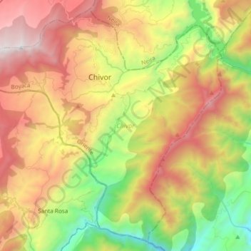
Name: Chivor topographic map, elevation, terrain.
Location: Chivor, Oriente, Boyacá, Colombia (4.79116 -73.44503 4.92884 -73.29693)
Average elevation: 1,801 m
Minimum elevation: 646 m
Maximum elevation: 3,071 m
Other topographic maps
Click on a map to view its topography, its elevation and its terrain.
Sogamoso
Sogamoso (Spanish pronunciation: [soɣaˈmoso]) is a city in the department of Boyacá of Colombia. It is the capital of the Sugamuxi Province, named after the original Sugamuxi. Sogamoso is nicknamed "City of the Sun", based on the original Muisca tradition of pilgrimage and adoring their Sun god Sué at the…
Average elevation: 2,901 m
Tunja
Tunja has a population of 172,548 inhabitants according to the 2018 Census. 0.1% of the city is indigenous, 0.4% is black, and 99.5% is white and Mestizo. It is located in central Colombia. The city centre is at an elevation of 2,820 metres (9,250 ft) above sea level.
Average elevation: 2,824 m