
Bolinas topographic map
Interactive map
Click on the map to display elevation.
About this map
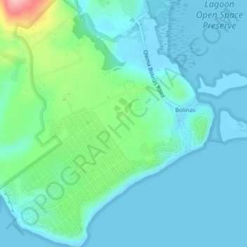
Name: Bolinas topographic map, elevation, terrain.
Average elevation: 28 m
Minimum elevation: -1 m
Maximum elevation: 149 m
Bolinas sits at an elevation of 36 feet (11 m) above sea level. It is bound on the northeast by Bolinas Lagoon and Kent Island and on the south by Bolinas Bay and Duxbury Point. According to the United States Census Bureau, the CDP has a total area of 5.8 square miles (15 km2), all of it land. The GNIS has cited archaic alternate town-names, including "Ballenas", "Baulenas", "Baulings", and "Bawlines".