
Luoyang topographic map
Interactive map
Click on the map to display elevation.
About this map
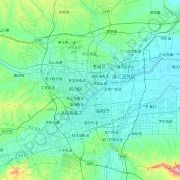
Name: Luoyang topographic map, elevation, terrain.
Location: Luoyang, Xigong District, Luoyang City, Henan, 471000, China (34.49569 112.26096 34.81569 112.58096)
Average elevation: 224 m
Minimum elevation: 115 m
Maximum elevation: 889 m
Other topographic maps
Click on a map to view its topography, its elevation and its terrain.
Yanshi District
Yanshi District, Luoyang, Henan, 471943, China
Average elevation: 271 m