
Matheran topographic map
Interactive map
Click on the map to display elevation.
About this map
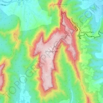
Name: Matheran topographic map, elevation, terrain.
Average elevation: 325 m
Minimum elevation: 43 m
Maximum elevation: 806 m
Other topographic maps
Click on a map to view its topography, its elevation and its terrain.
Tamnath
India > Maharashtra > Karjat
Tamnath, Karjat, Raigad, Maharashtra, 410201, India
Average elevation: 110 m
Karjat
India > Maharashtra > Karjat
Karjat, Raigad, Maharashtra, 410201, India
Average elevation: 109 m
Khandas
India > Maharashtra > Karjat > Khandas
Khandas, Karjat, Raigad, Maharashtra, India
Average elevation: 202 m