
Ruski Bród topographic map
Interactive map
Click on the map to display elevation.
About this map
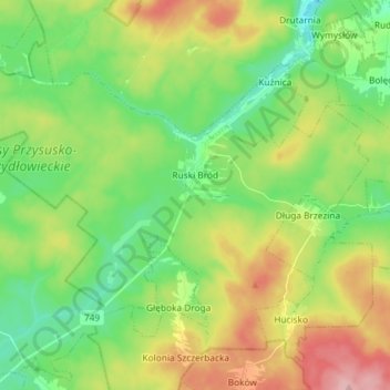
Name: Ruski Bród topographic map, elevation, terrain.
Average elevation: 269 m
Minimum elevation: 214 m
Maximum elevation: 361 m
Other topographic maps
Click on a map to view its topography, its elevation and its terrain.
Wysokin
Poland > Masovian Voivodeship > Przysucha County
Wysokin, gmina Odrzywół, Przysucha County, Masovian Voivodeship, 26-425, Poland
Average elevation: 152 m
Podczasza Wola
Poland > Masovian Voivodeship > Przysucha County
Podczasza Wola, gmina Klwów, Przysucha County, Masovian Voivodeship, Poland
Average elevation: 168 m
Kozłowiec
Poland > Masovian Voivodeship > Przysucha County
Kozłowiec, gmina Przysucha, Przysucha County, Masovian Voivodeship, Poland
Average elevation: 264 m
Przysucha
Poland > Masovian Voivodeship > Przysucha County > Przysucha > Przysucha
Przysucha, gmina Przysucha, Przysucha County, Masovian Voivodeship, 26-400, Poland
Average elevation: 227 m