Geolocate

Johns Creek topographic map

Interactive map

Click on the map to display elevation.

About this map

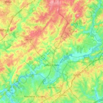
Name: Johns Creek topographic map, elevation, terrain.

Location: Johns Creek, Fulton County, Georgia, United States (33.98539 -84.28588 34.09068 -84.09769)

Average elevation: 314 m

Minimum elevation: 266 m

Maximum elevation: 380 m

Johns Creek is located in northeastern Fulton County and is centered at 34°1′44″N 84°11′55″W / 34.02889°N 84.19861°W / 34.02889; -84.19861 (34.0289259, -84.1985790). The elevation ranges from 880 feet (270 m) above sea level along the Chattahoochee River to 1,180 feet (360 m) in the Ocee area along the Alpharetta border. Johns Creek is bounded to the south by the Chattahoochee River and Gwinnett County, and on the northeast by McGinnis Ferry Road and Forsyth County. It is bounded by Roswell to the west, Alpharetta to the northwest, Suwanee to the east, and Duluth, Berkeley Lake, and Peachtree Corners to the south. Downtown Atlanta is 27 miles (43 km) to the southwest.

Wikipedia (CC-BY-SA 3.0)

Other topographic maps

Click on a map to view its topography, its elevation and its terrain.

Union City

United States > Georgia > Fulton County

Union City, Fulton County, Georgia, United States

Average elevation: 284 m

Roswell

United States > Georgia > Fulton County

Roswell, Fulton County, Georgia, United States

Average elevation: 316 m

Shake Rag

United States > Georgia > Fulton County > Johns Creek

Shake Rag, Johns Creek, Fulton County, Georgia, 30095, United States

Average elevation: 300 m

Bamboo Forest

United States > Georgia > Fulton County > Sandy Springs

Bamboo Forest, Sandy Springs, Fulton County, Georgia, 30339, United States

Average elevation: 278 m

Atlanta

United States > Georgia > Fulton County

Atlanta, Fulton County, Georgia, United States

Average elevation: 284 m

Sandy Springs

United States > Georgia > Fulton County

Sandy Springs, Fulton County, Georgia, United States

Average elevation: 301 m

South Fulton

United States > Georgia > Fulton County

South Fulton, Fulton County, Georgia, United States

Average elevation: 272 m

Chattahoochee Hills

United States > Georgia > Fulton County

Chattahoochee Hills, Fulton County, Georgia, United States

Average elevation: 261 m

Piedmont Park

United States > Georgia > Fulton County > Atlanta

Piedmont Park, Atlanta, Fulton County, Georgia, 30306, United States

Average elevation: 283 m

Boulder Park

United States > Georgia > Fulton County > Atlanta

Boulder Park, Atlanta, Fulton County, Georgia, 30336, United States

Average elevation: 257 m

East Point

United States > Georgia > Fulton County

East Point, Fulton County, Georgia, 30344, United States

Average elevation: 295 m

Atlanta

United States > Georgia > Fulton County

Atlanta, Fulton County, Georgia, 30303, United States

Average elevation: 285 m

Johns Creek

United States > Georgia > Fulton County > Johns Creek > Johns Creek

Johns Creek, Fulton County, Georgia, 30097, United States

Average elevation: 305 m

Roswell

United States > Georgia > Fulton County > Roswell

Roswell, Fulton County, Georgia, 30077, United States

Average elevation: 312 m

Alpharetta

United States > Georgia > Fulton County > Alpharetta

Alpharetta, Fulton County, Georgia, 300009, United States

Average elevation: 325 m

Johns Creek

United States > Georgia > Fulton County > Johns Creek

Johns Creek, Fulton County, Georgia, 30097, United States

Average elevation: 314 m

Simsville

United States > Georgia > Fulton County > Atlanta > Simsville

Simsville, Atlanta, Fulton County, Georgia, 30318, United States

Average elevation: 275 m

Alpharetta

United States > Georgia > Fulton County

Alpharetta, Fulton County, Georgia, United States

Average elevation: 324 m

Milton

United States > Georgia > Fulton County

Milton, Fulton County, Georgia, 30004, United States

Average elevation: 330 m

Mountain Park

United States > Georgia > Fulton County

Mountain Park, Fulton County, Georgia, United States

Average elevation: 312 m

Palmetto

United States > Georgia > Fulton County

Palmetto, Fulton County, Georgia, 30268, United States

Average elevation: 291 m