
Sparta Township topographic map
Interactive map
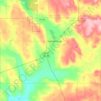
Click on the map to display elevation.
About this map
Name: Sparta Township topographic map, elevation, terrain.
Average elevation: 483 m
Minimum elevation: 391 m
Maximum elevation: 584 m
The elevation of Sparta Township ranges from a low of 1,320 feet at East Branch of Oil Creek to 1,913 feet (also highest point in Crawford County) in the northeastern part of the township. Eastman Hill, in the eastern part of the township, is the most prominent ridge in the township. Tributaries of Oil Creek, such as Stranahan Run, Patrick Run, Coon Run, Britton Run, Twomile Creek, and Fivemile Creek, drain most of the township with a small portion in the northeastern part being drained by Brokenstraw Creek tributaries. Wetlands in the county are mostly clustered around Clear Lake with smaller amounts along Fish Flats at Fivemile Creek and an area in the southeast part of the township.