
Ambil Odha topographic map
Interactive map
Click on the map to display elevation.
About this map
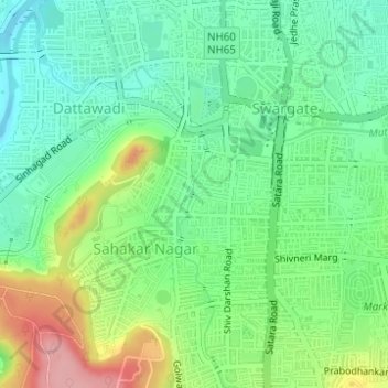
Name: Ambil Odha topographic map, elevation, terrain.
Location: Ambil Odha, Pune, Pune City, Pune, Maharashtra, 411001, India (18.47952 73.83859 18.50878 73.85396)
Average elevation: 589 m
Minimum elevation: 542 m
Maximum elevation: 678 m
Other topographic maps
Click on a map to view its topography, its elevation and its terrain.
Shaniwarwada
India > Maharashtra > Pune
Shaniwarwada, Shivaji Road, Kasba Peth, Pune, Pune District, Maharashtra, 411002, India
Average elevation: 560 m
Koregaon Park
India > Maharashtra > Pune
Koregaon Park, Suyojan Society, Ghorpuri, Pune, Maharashtra, 411001, India
Average elevation: 555 m
Vetal Tekdi
India > Maharashtra > Pune
Vetal Tekdi, Pune, Maharashtra, 411053, India
Average elevation: 622 m