
Ko Lanta topographic map
Interactive map
Click on the map to display elevation.
About this map
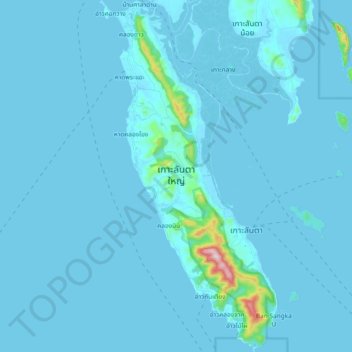
Name: Ko Lanta topographic map, elevation, terrain.
Location: Ko Lanta, Provinz Krabi, Thailand (7.46710 99.01851 7.65154 99.11100)
Average elevation: 16 m
Minimum elevation: -1 m
Maximum elevation: 467 m
Other topographic maps
Click on a map to view its topography, its elevation and its terrain.
หมู่เกาะพีพี
Thailand > Provinz Krabi > หาดแหลมทอง
หมู่เกาะพีพี, หาดแหลมทอง, Provinz Krabi, Thailand
Average elevation: 2 m