
Nördlingen topographic map
Interactive map
Click on the map to display elevation.
About this map
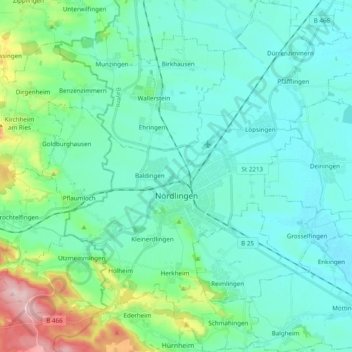
Name: Nördlingen topographic map, elevation, terrain.
Location: Nördlingen, Landkreis Donau-Ries, Bavaria, Germany (48.79459 10.42648 48.92256 10.59398)
Average elevation: 453 m
Minimum elevation: 408 m
Maximum elevation: 648 m
Other topographic maps
Click on a map to view its topography, its elevation and its terrain.
Ries
Germany > Bavaria > Landkreis Donau-Ries
Ries, Landkreis Donau-Ries, Bavaria, Germany
Average elevation: 484 m
Harburg (Schwaben)
Germany > Bavaria > Landkreis Donau-Ries
Harburg (Schwaben), Landkreis Donau-Ries, Bavaria, 86655, Germany
Average elevation: 473 m
Rain
Germany > Bavaria > Landkreis Donau-Ries
Rain, Rain (Schwaben), Landkreis Donau-Ries, Bavaria, 86641, Germany
Average elevation: 414 m
Hühnerberg
Germany > Bavaria > Landkreis Donau-Ries > Harburg (Schwaben)
Hühnerberg, Harburg (Schwaben), Landkreis Donau-Ries, Bavaria, 86655, Germany
Average elevation: 436 m
Donauwörth
Germany > Bavaria > Landkreis Donau-Ries
Donauwörth, Landkreis Donau-Ries, Bavaria, 86609, Germany
Average elevation: 443 m